Maps
![Item #20128552 [Box Title:] The Silent Teacher! Wiggin's Sectional Geography of the United States...](https://eclectibles.cdn.bibliopolis.com/pictures/20128552_1.jpeg?width=320&height=427&fit=bounds&auto=webp&v=1772545513)
Dissected Puzzle Map,Geography,Learning Through Play
New Haven and New York: D. and M. C. Wiggins, 1870s. A complete example of a double-sided "Dissected Puzzle Map", offering young ones the opportunity to learn about geography through interactive play. When completed, a map of the United States is revealed with geography trivia questions at the bottom. Each.....
Price: $450.00

Cartography,R.O.T.C.,Military Publishing
Harrisburg, Pennsylvania: The Military Service Publishing Co., c.1941. An educational set of protractors and a large map published "for use with R.O.T.C. Manuals for The Military Service Publishing Company". The Company, most active in the 1930s and 1940s, published textbooks and educational materials for R.O.T.C. programs and the military, and.....
Price: $150.00

ABAA-HOLIDAY-2025,Geography, Early Learning,
New York: McLoughlin Bros. 1883. A paper on board covered box with chromolithograph label reading "Improved Geographical Cards". The vignette depicts three (3) children playing the game. Includes 4pp. instructions and over 200 geographical cards. The pamphlet with a copyright by Freeman & Riddle is used interchangeably for the Improved.....
Price: $400.00
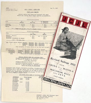
Cruises and Sailing Trips
Printed in the Netherlands-East Indies: Albrecht & Co. Batavia-Centrum, 1933. The January 1933 sailing schedule for "Java-China-Japan Lijn", a Dutch sailing company that catered to English-speaking tourists in Indonesia from Australia and America, throughout the 1930s and 1940s. Includes a list of travel agents for booking, and a full listing.....
Price: $225.00
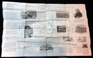
Historical Memorabilia, St Paul, Pictorial Maps
St. Paul Minnesota: 1903. A 21 3/4" x 33" illustrated historical map and tableau. It includes a street map of Water Street through fourth St. and Wabasha through Robert St. Information on the First Chapel 1841, the Cathedral, St. Peter's Church at Mendota, Mgr. A. Ravouz, Our Benefactors and much.....
Price: $150.00

Climatology, Meteorology, New England
Haverhill, New Hampshire: 1898. A letter handwritten in pencil on the back of a weather map published by the U.S. Department of Agriculture, showing the upcoming forecast for Boston on Monday, August 8, 1898. Includes a temperature chart and a weather map with isobars/isotherms to show changes in air pressure.....
Price: $150.00
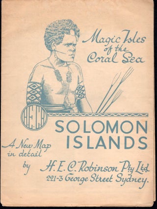
maps, Solomon Islands, Military History, WWII, Signal Corps
Sydney, Australia: H. E. C. Robinson Pty. Ltd., [1943-1945]. A map of the British Solomon Islands, specifically: Choiseul, Vella Lavella, Ganongga, Gizo, Kolombangara, New Georgia, Rendova, Tetepare, Vangunu, Gatukai, Santa Isabel Island, Florida Island, Malaita, Bougainville, Shortland Island and San Cristoval. The map shows a variety of government and missions.....
Price: $150.00

Miniature and Micro,Maps,New York City Subway,History of Public Transport
N.pl: Micromap Inc, 1980s. A wallet-sized "micro" map of the New York City Subway System, published in the early 1980s. To use the map, the user simply opens the map into its cube shape, then peers through the small round plastic magnifying glass on the front panel. The cube can.....
Price: $200.00

Land Development, History of Providence, Surveying
Providence, Rhode Island: Cushing & Walling, 1848. A scaled plan for land development by Providence-based surveyors Cushing & Walling, showing several lots off North Main Street including "A.E. Arnold's Store", "Aborn's Store", the "Jackson Estate", and four other lots owned by Arnold and Aborn. Measures 7.5" by 12.75", plans in.....
Price: $200.00
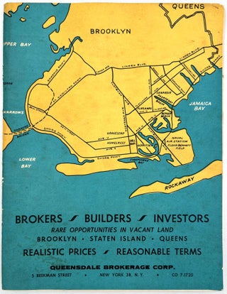
Urban Development, History of New York
Brooklyn, New York: Queensdale Brokerage Corp. 1962. A listing "of choice parcels of vacant land, located in Brooklyn, Queens and Staten Island" for sale by the Queensdale Brokerage Corp. Includes maps of the areas, with some parcels marked as "sold", as well as a price sheet with lot numbers and.....
Price: $350.00
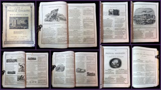
geography, arithmetic, verse, poetry, education, maps, subscription publications
Cincinnati, OH: 1852. A textbook, only sold by subscription, that seeks to teach the reader arithmetic and world geography by using verse, often rhyming verse, to help the reader memorize the important terms and formulas. For example, in describing the divisions of land, the following poem is used: "Of.....
Price: $125.00
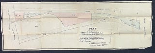
Land Development, Land Plat, Historical Memorabilia
Philadelphia, PA: 1865. A 10 1/2" x 32" Plan of the Estate of Thomas Woodward, deceased, in the Twenty-fourth Ward, Philadelphia. To be sold at 12 O'clock noon at the Phila. Exchange, by M. Thomas & Son, Auctioneers. Plat by M. H. Traubel. Well annotated and marked. Watercolor highlights. Woodward.....
Price: $225.00
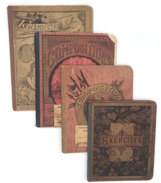
ABAA-RBMS-2026,Education, Copybooks, Maps
Orion, Illinois: 1888. Four (4) manuscript composition notebooks belonging to Myrtle Fulton, a talented Fulton County, Illinois student aged 16 in 1888. Myrtle had a remarkable talent for cartography; one would not know from her drawings of the continents that she was only 16 when she compiled these notebooks...
Price: $550.00

Cartography,School Project,Naive
United States: 1950s. A charming school cartography project signed at he bottom by "Tommy Whipple", aged 8 or 9. The project depicts the voyage of maritime explorer Jacques Cartier, the first European to map the Gulf of St. Lawrence. The student drew the map with pencil, then went over it.....
Price: $225.00